 Skip to content


NHS Drone Deliveries Cut Test Sample Times Across South West London
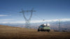
NHS drone deliveries are now a core part of pathology logistics for up to 1.8 million people across south west London. Since February 2026, drones have carried patient samples from the Nelson Health Centre in Raynes Park to the South...
Read more
DJI Releases SAIL III OSO Declarations For Dock 3 And Matrice 4D
DJI has published a complete package of SAIL III OSO declarations for the DJI Dock 3 and Matrice 4D Series, giving operators manufacturer-backed evidence to support SORA applications in EASA member states. Announced on 14 July 2026, the package covers...
Read more

World Cup 2026 Drone Show Lights Up The Manhattan Skyline
A spectacular World Cup 2026 drone show has illuminated the skies over the New York metropolitan area ahead of the tournament final between Spain and Argentina. Thousands of spectators watched from Liberty State Park as synchronised drones painted the World...
Read more

How An Indigenous Community Built A Dock First Responder Programme
An Indigenous community on Manitoulin Island has built one of the most compelling community-led drone programmes in North America, using DJI docking stations and enterprise drones to protect 9,400 members across 65,000 hectares of land and 220 kilometres of shoreline....
Read more
DJI Ends Support For The Zenmuse Z30, XT S And More In September 2026
DJI is retiring service and support for four older enterprise products on 1 September 2026, giving operators a firm deadline to plan their replacements. After that date, the DJI Zenmuse Z30 zoom camera, the Zenmuse XT S thermal camera, the...
Read more
DJI Matrice 400 Firmware v17.02.50.07 Adds AP100 Parachute Support
DJI has released firmware version v17.02.50.07 for the DJI Matrice 400, and the headline change is native support for the new DJI AP100 Parachute. With this update installed, the M400 can run the parachute as a fully integrated payload, opening...
Read more

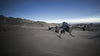
How DJI Put Its Drones To The Test On Mount Everest In 2026
DJI has completed three high-altitude missions on Mount Qomolangma, also known as Mount Everest, using drones to move supplies, map hazardous terrain, and gather climate data at extreme altitude. The 2026 tests put the new DJI FlyCart 100 delivery drone...
Read more

Do You Need Internet To Fly A Drone?
Short answer, no. You do not need internet or WiFi to fly a drone. Flight is controlled by a dedicated radio link between your controller and the aircraft, and positioning comes from GPS satellites that broadcast one way to the...
Read more

How LiDAR Drones And The DJI Zenmuse L3 Solve City Flooding
A flood-hit town in the Philippines has shown how LiDAR drones can turn a stubborn drainage problem into a solvable engineering task. Using the DJI Zenmuse L3 LiDAR payload, a survey team mapped 470 hectares of Mariveles in Bataan in...
Read more
Drone Delivery Vs Ground Robot Delivery: Which Will Win?
Drone delivery has long been sold as the future of last-mile logistics, with parcels flying over traffic and hot food arriving in minutes. Meanwhile, ground delivery robots have quietly rolled along pavements doing the unglamorous work. So which one actually...
Read more

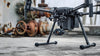
DJI Launches AP100 Parachute For The Matrice 400
The DJI AP100 Parachute is DJI Enterprise's first purpose-built parachute recovery system for the DJI Matrice 400, and it is the safety layer that moves an M400 programme from line of sight only to flying over people and beyond visual...
Read more

1,100 Drones Seized At The FIFA World Cup And The Lesson For Pilots
Authorities have detected more than 1,100 drones near FIFA World Cup venues across the United States, and the FBI says it has already seized over 500 of them. The figures show just how tightly airspace is being controlled around the...
Read more


