Skip to content


How Drone Mapping Helps Icefall Doctors On The Khumbu Icefall
- by Stefan Gandhi
Drone mapping has transformed one of the most dangerous jobs on Earth. In spring 2026, a DJI Matrice 4E mapped more than 3 square kilometres of Everest's Khumbu Icefall in just 3.5 hours, producing a high-precision 3D model that helps the Sherpas known as Icefall Doctors plan safe climbing routes without repeatedly exposing themselves to collapsing ice. A survey that once took weeks on foot now takes an afternoon in the air.
Who The Icefall Doctors Are
Every climbing season, before any paying climber sets foot above Base Camp, a small team of Sherpas enters the Khumbu Icefall first to establish the route. Known as the Icefall Doctors, they fix the ropes and aluminium ladders that every expedition depends on to cross the shifting maze of crevasses and ice towers.
It is among the most hazardous work in mountaineering. The icefall moves every day, seracs collapse without warning, and the route must be checked and repaired constantly throughout the season. Traditionally, all of that assessment happened on foot, one careful step at a time.
The Serac Field That Sealed The Route
In spring 2026, a rare, large-scale serac field formed across the Khumbu Icefall. Overnight, the established summit route was sealed off, leaving hundreds of climbers stranded at Base Camp with no safe way through.
The Icefall Doctors needed a way to see the entire icefall at once, with enough precision to plan a new line through terrain that punishes guesswork. The answer lifted off from a Sherpa's hands.
How The DJI Matrice 4E Mapped The Icefall
Working with Nepali drone specialists Airlift Technology, the team deployed a DJI Matrice 4E on pre-planned mapping routes above the icefall, capturing every crevasse and pressure shift below. The imagery was processed into a detailed 3D model of the entire icefall.
Raj Bikram Maharjan, CEO of Airlift Technology, explained that the 3D mapping lets the Icefall Doctors and mountaineers fix the route 'without even climbing the icefall', reducing risk to their lives while increasing efficiency by calculating exactly where to place ladders and which way to run the ropes.
The model is precise enough to measure individual crevasses, giving the team hard numbers on gaps and slopes before anyone commits to carrying a ladder to the spot.
From Weeks Of Risk To Hours Of Data
The efficiency gain is dramatic. Surveying a route through the icefall previously took two to three weeks of exposed, physical reconnaissance, and a ground-based LiDAR survey in 2019 took over two months to complete. In 2026, the Matrice 4E collected high-precision 3D data across more than 3 square kilometres in 3.5 hours.
The benefits reach beyond this season's route. The same 3D models give scientists and environmentalists a repeatable record of how the icefall is changing, building a digital archive of one of the world's most dynamic glacial features year after year.
What Drone Mapping Means Beyond Everest
The principle proven on the Khumbu Icefall applies anywhere terrain is dangerous, remote, or fast-changing. UK surveyors use the same aircraft and workflow to map quarries, construction sites, coastal erosion, and infrastructure corridors, replacing hours of ground work with minutes of flight and centimetre-level 3D outputs.
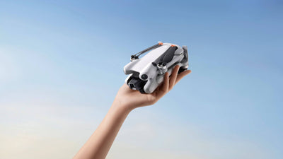
The Matrice 4E carries a mechanical-shutter wide camera, tele cameras, and laser rangefinder in a platform compact enough to launch from a hand at Base Camp. When the same tool serves both an Everest route-fixing team and a site engineer in Yorkshire, drone mapping has stopped being a niche capability and become standard practice.
FAQs
What do the Icefall Doctors do on Everest?
The Icefall Doctors are a team of Sherpas who establish and maintain the climbing route through the Khumbu Icefall each season, fixing the ropes and ladders every expedition uses. They enter the icefall first and repair the route continually as the ice shifts throughout the season.
Why is the Khumbu Icefall so dangerous?
The Khumbu Icefall is a constantly moving section of glacier between Everest Base Camp and Camp One, full of deep crevasses and unstable ice towers called seracs that can collapse without warning. Because it changes daily, a route that was safe yesterday can be lethal today.
What is drone mapping?
Drone mapping uses a drone flying pre-planned routes to capture overlapping images or laser scans of an area, which software processes into accurate 2D maps and 3D models. It allows teams to measure, inspect, and monitor terrain without physically walking it.
What is the DJI Matrice 4E used for?
The DJI Matrice 4E is an enterprise mapping and inspection drone with a mechanical-shutter camera, tele cameras, and a laser rangefinder. It is used for high-precision surveying, 3D modelling, construction progress tracking, and inspection work, including the 2026 mapping of the Khumbu Icefall.
Final Thoughts
The Khumbu Icefall will never be safe, but the people who work inside it now carry a decisive advantage. A 3.5 hour drone mapping flight replaced weeks of life-threatening reconnaissance, and the resulting 3D model guides every ladder and rope placement on the mountain's most feared section. It is one of the clearest demonstrations yet that drone mapping saves not just time and money, but lives.
Explore the DJI Matrice 4 Enterprise at the Coptrz official online store, or talk to our mapping specialists about building a survey capability at sales@coptrz.com or on 0330 111 7177.