Skip to content


DJI Zenmuse L3 LiDAR Transforms Forest Mapping Accuracy
- by Stefan Gandhi
Forest environments present some of the most demanding challenges in professional surveying. Dense canopies, uneven terrain, and layered vegetation make it incredibly difficult to gather the ground-level data that forestry professionals, ecologists, and land managers actually need. Traditional aerial photogrammetry struggles to see beneath the tree line, leaving critical information gaps that compromise the quality of terrain models and vegetation assessments.
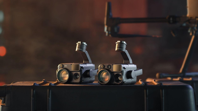
The DJI Zenmuse L3 LiDAR sensor changes that equation entirely. Designed for professional-grade surveying workflows, this payload delivers the canopy penetration, data density, and software integration that forestry teams need to work with genuine precision. Here is a closer look at what the Zenmuse L3 brings to forest mapping and why it represents a significant step forward for surveying professionals across the UK.
The Core Challenge In Forest Surveying
Accurate forestry data is not simply about capturing a top-down view of trees. Ground surveyors and forestry managers require detailed terrain models that show the shape of the land beneath the canopy, along with vegetation data precise enough to support individual tree analysis, timber volume estimates, and habitat assessments.
Photogrammetry alone cannot reliably deliver this. Laser-based LiDAR, on the other hand, fires pulses of light that can pass through gaps in the canopy and return data from multiple layers simultaneously, including the forest floor. The key is the quality and specification of that LiDAR system, and this is where the Zenmuse L3 stands apart.
Advanced LiDAR Technology At The Heart Of The L3
The Zenmuse L3 uses a 1535 nm high-energy laser combined with a small laser spot size and support for multiple returns. This specification is particularly important in forestry contexts. The high-energy output drives greater penetration through thick canopy layers, while the small spot size improves the spatial resolution of the data collected. Multiple return capability means a single laser pulse can register contact with a branch, a mid-storey shrub, and the ground surface in one pass, building a rich, multi-layered point cloud that reflects the true complexity of the forest structure.
The result is a high-density capture of ground points that would simply not be accessible using optical sensors alone. For surveyors working on dense woodland surveys, plantation assessments, or environmental monitoring projects, this translates into significantly more reliable terrain data.
Real-Time Terrain Following For Consistent Data Quality
Forest terrain is rarely flat. Slopes, gullies, ridgelines, and undulating ground all affect the consistency of data capture if the drone is flying at a fixed altitude above the launch point. Inconsistent altitude means inconsistent point density, which in turn affects the accuracy of the final deliverables.
When paired with the DJI Matrice 400, the Zenmuse L3 supports real-time terrain following. The system continuously adjusts flight altitude relative to the ground surface beneath it, maintaining a consistent sensor-to-ground distance throughout the mission. This is particularly valuable in complex woodland environments where elevation changes significantly across the survey area, ensuring that every part of the site receives the same quality of data capture regardless of topographic variation.
Multi-Angle Capture For Richer Vegetation Data
Terrain mapping is only one part of a complete forestry survey. Vegetation information, including the shape, height, and structure of individual trees, requires a different capture approach. The Zenmuse L3 features an articulating gimbal that enables oblique photogrammetry flight routes, allowing the sensor to capture data at multiple angles rather than just looking straight down.
This multi-angle capability produces far more detailed vegetation point clouds. Instead of capturing only the tops of trees, the sensor can collect data from multiple perspectives in a single flight, filling in the sides of canopies and capturing structural information that vertical-only passes would miss. For forestry professionals who need accurate representations of stand structure, this is a meaningful operational advantage.
An Integrated Software Workflow From Capture To Deliverable
Raw point cloud data is only as useful as the tools available to process it, and the Zenmuse L3 is designed to work within a cohesive software ecosystem that takes survey data from capture to professional deliverable efficiently.
DJI Terra handles the initial data processing, offering one-click export of point clouds, digital elevation models (DEMs), and a wide range of compatible file formats. This simplifies the handoff between field capture and office processing, removing much of the manual conversion work that can slow down production workflows.
From there, DJI Modify provides fine-grained terrain classification tools, allowing operators to separate ground returns from vegetation, classify different surface types, and produce terrain models that meet professional survey standards. The level of classification control available in DJI Modify makes it possible to create outputs that are suitable for submission to clients, regulatory bodies, or as inputs into wider GIS workflows.
For vegetation analysis, the workflow extends further. Once point cloud data has been classified in DJI Modify, it can be imported into LiDAR360, a specialist forestry analysis platform. Within LiDAR360, individual tree segmentation algorithms can identify and isolate separate trees from the point cloud, extracting precise data on tree positions, canopy heights, stem counts, and ultimately supporting timber volume assessments. The ability to move from raw LiDAR capture to individual tree metrics within an integrated workflow significantly reduces the time and manual effort required to produce these outputs.
Practical Benefits For UK Forestry Professionals
For drone operators and forestry consultants working in the UK, the Zenmuse L3 addresses several practical pain points. Survey efficiency improves because the real-time terrain following and high-energy laser reduce the need for repeat flights or supplementary ground data collection. Data completeness improves because multi-return capture and oblique flight routes ensure that both ground terrain and vegetation structure are captured in a single mission. And workflow efficiency improves because the DJI Terra, DJI Modify, and LiDAR360 pipeline reduces the number of third-party tools and manual processing steps required to reach final deliverables.
Whether managing commercial timber plantations, conducting biodiversity surveys, or producing habitat models for environmental impact assessments, the combination of hardware capability and integrated software makes the Zenmuse L3 a credible solution for professional forestry operations of all scales.
FAQs
What is the DJI Zenmuse L3 used for?
The DJI Zenmuse L3 is a professional LiDAR payload designed for aerial surveying applications. It is particularly suited to forestry mapping, terrain modelling, vegetation analysis, and any environment where ground data needs to be captured beneath a dense canopy. It is also used in infrastructure inspection, corridor mapping, and large-scale topographic surveys.
How does LiDAR penetrate forest canopy?
LiDAR systems like the Zenmuse L3 emit laser pulses that travel through small gaps in the forest canopy. Because each pulse can register multiple returns, a single shot can record contact with the canopy surface, branches at different heights, and the ground surface beneath. High-energy output and a small laser spot size improve the density of ground returns even in thick vegetation.
What drone is compatible with the DJI Zenmuse L3?
The DJI Zenmuse L3 is designed to work with the DJI Matrice 400 series. When paired with the Matrice 400, operators can take advantage of real-time terrain following, which adjusts flight altitude dynamically to maintain consistent data capture across complex topography.
Can the Zenmuse L3 be used for individual tree segmentation?
Yes. The Zenmuse L3's articulating gimbal supports oblique flight routes that capture multi-angle vegetation data, producing detailed point clouds of individual trees. When processed through DJI Modify and imported into LiDAR360, the data supports individual tree segmentation, providing outputs such as tree positions, heights, canopy dimensions, and stem counts for timber volume assessments.
What software works with the DJI Zenmuse L3?
The Zenmuse L3 integrates with DJI Terra for point cloud processing and data export, DJI Modify for terrain classification and deliverable production, and LiDAR360 for advanced forestry analysis including individual tree segmentation. Together, these tools form a complete end-to-end workflow from flight planning to professional output.
Is LiDAR better than photogrammetry for forestry surveys?
For applications that require accurate ground terrain data beneath forest canopy, LiDAR offers a significant advantage over photogrammetry. Photogrammetry relies on visible light and struggles to see through or between leaves and branches. LiDAR laser pulses can penetrate vegetation and return data from the ground surface, making it the preferred technology for forestry terrain mapping, volumetric analysis, and vegetation structure surveys.
Conclusion
The DJI Zenmuse L3 represents a practical, high-performance solution for the professional forestry surveying challenges that have historically required substantial resources and extended fieldwork. Its combination of a high-energy 1535 nm laser, multiple return capability, articulating gimbal, real-time terrain following, and integration with DJI Terra, DJI Modify, and LiDAR360 creates a workflow that is both comprehensive and operationally efficient.
For UK drone professionals and forestry consultants looking to upgrade their survey capability, the Zenmuse L3 offers the precision and reliability that demanding clients and complex sites require.
To order the DJI Zenmuse L3 or speak to a specialist about pairing it with the right platform for your operations, visit the Coptrz official online store for expert advice and online purchases.