Skip to content


DJI Advanced GEO Training Now Available In The UK With Coptrz
- by Stefan Gandhi
Buying a survey drone is the easy part. Getting consistent, client ready data out of it is where most geospatial teams struggle. DJI's official Advanced GEO Products Training has now arrived in the UK, delivered locally by Coptrz as a DJI certified delivery partner. This article explains what the DJI GEO training covers, who it is designed for, and how it differs from a pilot qualification.
What Is DJI Advanced GEO Products Training
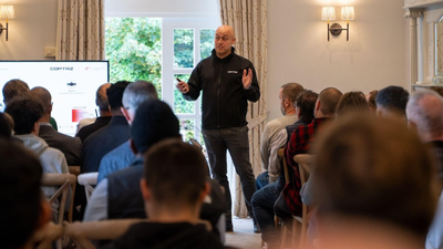
DJI Advanced GEO Products Training is an official DJI curriculum focused on getting the full capability from DJI's geospatial hardware and software. It covers the complete workflow, from mission planning in the field through to a processed deliverable, with an emphasis on practical flying rather than slide decks.
DJI designs the course content and certifies which dealers are allowed to deliver it. Coptrz is one of those certified partners, which means UK teams can now train to the same standard used across Europe without travelling abroad or relying on remote sessions from overseas. The programme is currently available in Europe only.
Why Geospatial Teams Need Official DJI Training
Most survey teams learn a new platform by trial and error. That often leads to default settings because nobody is sure what the alternatives do, reflights when data fails to process cleanly, and accuracy figures that are hard to evidence to a client.
There is also a business risk. When product knowledge sits with one person, the whole capability walks out of the door if they leave. Some teams even turn down jobs because nobody feels confident enough to quote for them.
Structured training fixes these problems by giving the whole team a repeatable method. Everyone works to the same process, deliverables become consistent, and you can put your capability in front of clients with confidence.
Four Things That Set DJI GEO Training Apart
Advanced Technique, Not The Basics
The training goes beyond introductory flying to cover advanced operational technique, complete workflow solutions and in depth practice in the field.
Standardised Content
Every course follows DJI's standardised design and training standards. That means consistent content, a compliant process and quality DJI stands behind, wherever the course is delivered.
Certified Delivery Partners Only
DJI selects and certifies the dealers permitted to run the training, then equips them to deliver it locally. Coptrz holds that certification in the UK.
Continuous Updates
Courses are developed per product category and updated in step with DJI firmware, payload and software releases. What you learn keeps pace with what you fly.
DJI GEO Courses For Matrice 4E And Zenmuse L3
Rather than one generic session, each course is built around a specific aircraft or payload so the training matches the kit your team actually operates.
Matrice 4E aircraft course. This course focuses on getting survey grade photogrammetry from the DJI Matrice 4E. It covers mission planning, capture settings, ground control and the full route from flight to processed model.
Zenmuse L3 payload course. This course teaches crews to work the DJI Zenmuse L3 LiDAR payload properly, including scan strategy, point density and accuracy, trajectory processing, and turning raw LiDAR into a deliverable you can hand to a client.
Training is priced per course, so you only pay for the products your team uses. Group bookings and multi course rates are available, and more courses are being added across DJI's geospatial range.
What The DJI GEO Training Syllabus Covers
The breakdown of training spans the full geospatial workflow:
- Mission planning for photogrammetry and LiDAR
- Flight height, speed, overlap and point density
- RTK, PPK and base station workflows
- Coordinate systems and height datums
- Control points and independent checkpoints
- LiDAR returns, scan patterns and trajectory processing
- DJI Terra processing, strip alignment and point cloud quality
- Accuracy checks and reporting
- Spotting poor data before leaving site
- Export formats and final deliverables
GEO Training Is Not A Pilot Qualification
It is worth being clear about this. The A2 CofC and RPC-L1 prove your competence to fly legally in UK airspace and are assessed against CAA requirements. They are a prerequisite for most commercial drone operations.
DJI Advanced GEO training is about product mastery. It proves your team can produce repeatable, quality controlled geospatial deliverables from specific DJI hardware and software. It has nothing to do with your permission to fly and everything to do with the quality of what you produce. Most teams need both, and Coptrz delivers both.
Who Should Book DJI GEO Training
The course is aimed at teams already flying DJI geospatial kit, or about to. That includes:
- Survey teams looking to improve accuracy and deliverables
- Geospatial managers who want consistent output across the team
- Drone service providers aiming to quote for a wider range of work
- Asset owners building in house capability and reducing outsourcing
Operators of the Matrice 400, Matrice 350 RTK, Matrice 4 Series, Zenmuse L3 and L2, Zenmuse P1 and DJI Terra are all well placed to benefit.
How To Register Your Interest
Registration is open now on the Coptrz DJI GEO training page. It takes around two minutes and simply tells the team what you operate. Coptrz will then get in touch to discuss your kit and goals, and you will get first refusal once dates and pricing are confirmed. Registering does not hold a place, take payment or commit you to anything.
FAQs
What is DJI Terra used for?
DJI Terra is DJI's mapping and processing software. It turns photogrammetry images and LiDAR data from aircraft such as the Matrice 4E and payloads like the Zenmuse L3 into 2D maps, 3D models and point clouds.
Do I need an A2 CofC to fly a survey drone?
For most commercial survey work in the UK, you need at least an A2 CofC or a GVC or RPC-L1, depending on the operation. DJI GEO training does not replace these, as it focuses on product workflow rather than flying legally.
What is the difference between RTK and PPK?
RTK applies positional corrections in real time during the flight, while PPK applies them after the flight during processing. Both improve positional accuracy, and the GEO training covers when and how to use each workflow.
Do I need to own DJI survey equipment to take the course?
The training is designed for teams that already fly DJI geospatial products or are about to. If you are still evaluating kit, Coptrz can talk you through the options when you register.
Where is DJI GEO training delivered?
In the UK, the course is delivered by Coptrz as a DJI certified delivery partner. The programme is currently available in Europe only.
Final Thoughts
DJI Advanced GEO Products Training gives UK survey and geospatial teams an official, standardised route to getting more from the Matrice 4E, Zenmuse L3 and DJI Terra. With courses that update as the products evolve, it is a practical way to protect your hardware investment and win more work.
Register your interest in DJI Advanced GEO training and be first to hear about UK course dates, content and pricing, with no commitment.