DJI Zenmuse L3 Vs L2: Which LiDAR Payload Is Right For You?
- by Stefan Gandhi
DJI has long been the name professionals trust when it comes to precision aerial surveying. From the early Zenmuse L1 to the highly capable L2, each generation has set a new standard for LiDAR mapping, 3D modelling, and terrain reconstruction. Now, with the arrival of the DJI Zenmuse L3, the bar has once again been raised, promising longer range, finer accuracy, and smarter workflows designed for the next era of geospatial data collection.
But how does the L3 truly compare to the L2? And more importantly, which one is right for your professional needs? Let’s take a closer look.
The Evolution Of DJI’s LiDAR Payloads
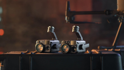
DJI’s Zenmuse range was created to simplify the complexities of LiDAR surveying. Mounted to compatible drones such as the Matrice 300, 350, and 400 RTK, these payloads bring together laser scanning, imaging, and inertial measurement in one compact, integrated solution.
The Zenmuse L2 became the go-to choice for surveyors, construction teams, and environmental professionals thanks to its accuracy, ease of use, and compatibility across multiple DJI platforms. Now, the Zenmuse L3 takes that same foundation and expands it with advanced optics, re-engineered sensors, and software intelligence designed to handle tougher terrains and higher data demands.
Key Improvements At A Glance
The Zenmuse L3 is not just an incremental upgrade. It is a full-scale leap in LiDAR technology:
-
Detection range up to 950 m at 10% reflectivity, more than double the L2’s effective distance.
-
Accuracy down to 2–4 cm vertically and 3–5 cm horizontally, ideal for precision-grade mapping.
-
16 returns per pulse (compared with L2’s 5), enabling deeper canopy penetration.
-
Dual 100 MP cameras with adjustable resolution between 25 and 100 MP, delivering sharper RGB colourisation.
-
Smaller laser spot size (≈ 41 mm @ 120 m), producing denser and more detailed point clouds.
-
Improved IMU with 2.5× the performance and auto-calibration on startup.
-
New scanning modes, including “Star Show” patterns for enhanced accuracy in complex vegetation.
-
Real-time Gaussian Splatting and Fusion Reconstruction, turning raw LiDAR data into instantly usable 3D visualisations.
- Extended operating range (–25 °C to 55 °C) and rugged IP54 protection for demanding environments.
DJI Zenmuse L3 Vs L2 Specification Comparison
| Feature | Zenmuse L2 | Zenmuse L3 |
|---|---|---|
| LiDAR Detection Range | 450 m @ 50% / 250 m @ 10% | Up to 950 m @ 10% reflectivity |
| Horizontal Accuracy | ±5 cm @ 150 m | ±3–5 cm (horizontal) / ±2–4 cm (vertical) |
| Returns Per Pulse | Up to 5 | Up to 16 |
| Laser Spot Size (@120 m) | ≈205 mm | ≈41 mm |
| IMU Performance | ±0.025° Roll/Pitch | 2.5× improvement, auto-calibration |
| RGB Camera | 20 MP (4/3” CMOS) | Dual 100 MP (adjustable, 1 s interval) |
| Scanning Modes | Linear | Linear / Star Show / Non-repetitive |
| FOV (LiDAR) | 70° × 75° | 80° × 80° |
| LRF Range | 500 m | 900 m |
| Protection Rating | IP54 | IP54 |
| Operating Temperature | –20 °C to 50 °C | –25 °C to 55 °C |
| Weight | 905 g | 1.6 kg |
| Compatible Platforms | M350 RTK / M300 RTK | M400 RTK only |
Greater Efficiency & Safety
For large-scale mapping and surveying, efficiency is everything. The Zenmuse L3 allows operators to fly higher while maintaining exceptional data quality, thanks to its extended detection range of up to 950 m. This means larger coverage areas in fewer flights and improved safety margins when surveying near obstacles, power lines, or unstable ground.
By capturing more from every flight, teams can complete projects faster without sacrificing precision, a crucial advantage for time-sensitive construction and inspection missions.
Unmatched Detail & Canopy Penetration
One of the standout improvements is the 16-return capability of the L3. This provides superior penetration through dense vegetation and canopy cover, allowing for clear ground detection even in forested areas. Combined with the smaller laser spot size, it produces richer point clouds and improved surface definition, ideal for forestry, archaeology, and environmental applications.
For professionals used to the L2’s reliable five returns, the jump to sixteen represents a new level of data density and clarity.
Faster Data To Insight
Speed matters not just in the air but also in post-processing. The Zenmuse L3 introduces real-time Gaussian splatting and fusion reconstruction, reducing the need for lengthy data conversion and manual editing. Operators can generate DSM, DEM, and 3D models directly from a single flight, transforming raw data into actionable deliverables faster than ever before.
This direct-to-output capability is particularly useful for survey firms handling multiple projects simultaneously. Less time processing means more time on deployment and client delivery.
Simplified Workflows
Surveying technology is only as good as the workflow behind it. The Zenmuse L3 simplifies operations through its auto-calibrating IMU, eliminating manual calibration routines that previously cost valuable time. Once powered on, the system automatically aligns its heading, pitch, and roll parameters, ready for flight in moments.
For field teams under tight deadlines or operating in harsh conditions, this reliability can make a measurable difference in project turnaround times.
Superior Imaging Performance
The dual 100 MP RGB cameras are a major leap from the L2’s single 20 MP sensor. Each camera captures ultra-high-resolution imagery that enhances LiDAR colourisation and photogrammetry outputs. Adjustable resolutions allow operators to balance between data density and efficiency depending on the mission type.
With a mechanical shutter lifespan of 500,000 cycles and an 80° × 80° field of view, the L3 provides complete coverage for mapping, modelling, and inspection in a single pass.
Software Integration With DJI Terra & DJI Modify
Hardware upgrades alone do not define the Zenmuse L3. Its full potential is unlocked when paired with the latest versions of DJI Terra and DJI Modify, where new tools streamline processing and analysis.
Key software advancements include:
-
Fusion Reconstruction for one-flight multi-output capture (2D maps, 3D models, Gaussian splats).
-
DSM/DEM Generation and Contour Mapping directly from L3 datasets.
-
Cluster Reconstruction for multi-computer workflows, accelerating large project processing.
-
Improved DJI Modify Rendering, optimised for 32 GB RAM workstations.
-
New Cross-Section and Classification Tools for automatic denoising and point separation.
- Visible Light Reconstruction, using the L3’s RGB imagery for photorealistic outputs (free for the first year).
Together, these enhancements mean less time waiting on renders and more reliable results, even on complex topographies or multi-layer environments.
Operational & Industry Benefits
From surveying open-pit mines to inspecting transmission towers, the Zenmuse L3 introduces tangible operational advantages:
-
Longer range and wider coverage reduce flight hours and operational costs.
-
Enhanced safety from higher-altitude operation.
-
Richer datasets allow for more detailed digital twins and reconstruction models.
-
All-in-one design eliminates complex payload setups.
- Improved environmental resilience ensures performance in demanding UK conditions.
In essence, the L3 transforms each flight into a complete capture event, providing colourised LiDAR, 3D mesh, and RGB imagery all at once.
FAQs
Is the Zenmuse L3 compatible with the M350 RTK?
No. The Zenmuse L3 is designed exclusively for the DJI Matrice 400 RTK, utilising its single-port installation and improved data transmission capabilities.
Can the Zenmuse L3 operate in cold or wet conditions?
Yes. The payload carries an IP54 rating and can operate in temperatures from –25 °C to 55 °C, making it suitable for UK winter operations and damp fieldwork.
Does the L3 require manual calibration like the L2?
No. Thanks to its auto-calibrating IMU, the L3 requires no manual setup, allowing operators to begin capturing data immediately after power-up.
How much heavier is the L3 compared to the L2?
At 1.6 kg, the L3 is heavier than the L2’s 905 g, but this additional weight accommodates new sensors, dual cameras, and improved optics.
What industries will benefit most from upgrading to the L3?
The L3 is ideal for surveying, construction, infrastructure, forestry, and environmental management, offering extended range, better canopy penetration, and faster data turnaround.
Conclusion
The DJI Zenmuse L3 lives up to its promise to 'see through, far and true'. With double the range, triple the returns, and revolutionary imaging and processing capabilities, it represents the next generation of professional aerial LiDAR.
For operators currently using the L2, the upgrade delivers tangible advantages: greater reach, higher fidelity, simplified workflows, and more accurate deliverables, all designed to meet the growing demands of modern surveying and inspection.
As data precision and efficiency become the cornerstone of competitive edge in the UK drone industry, the Zenmuse L3 offers professionals a clear advantage in performance, reliability, and long-term ROI.
Pre-order or learn more about the DJI Zenmuse L3 now on the Coptrz official online store.


