Introducing DJI Zenmuse L3: Everything You Need To Know
- by Stefan Gandhi
The rise of advanced aerial surveying has pushed LiDAR technology further and faster than many expected. Professionals across surveying, construction, utilities, mining and environmental sectors need tools that gather accurate data at scale, keep crews safe and compress long workflows into actionable deliverables. DJI has answered that demand with the Zenmuse L3, a new flagship LiDAR and imaging payload built for the DJI Matrice 400 platform.
The Zenmuse L3 brings a major step forward in range, accuracy, point density and imaging performance, creating a single integrated solution for complex terrain, long linear missions and high detail work such as power infrastructure and dense vegetation areas. With extended reach, higher precision and new intelligent features, it gives drone operators a powerful tool to deliver reliable survey outputs with speed and repeatability.
This article breaks down the key upgrades, system capabilities, software support and real-world benefits for organisations in the UK planning to modernise their aerial surveying toolkit.
Overview
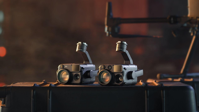
At its core, the Zenmuse L3 combines high-end LiDAR, dual Micro Four Thirds cameras and a refined inertial system in a compact package. The system is built for field reliability and accuracy across large environments, from quarries and wind farms to forestry survey corridors and railway assets.
Operators benefit from a working range suited to practical industry tasks, along with the ability to stretch further when the mission demands maximum reach. The system is also designed to perform in tough weather, maintain signal integrity and deliver clear data in mixed terrain.
Key capabilities include:
- Effective working range around 300 to 500 m
- Maximum reach up to 950 m at low reflectivity
- Typical accuracy between 2 and 4 cm
- Class 1 eye-safe laser system
- Wide operational temperature window with IP54 sealing
For UK surveyors, asset managers and inspection teams, this means the L3 can confidently support civil engineering tasks, highway planning, ecological studies and heritage mapping, while also meeting the demands of power utilities and heavy industry.
What Has Changed Compared To Previous Generations
DJI has continuously improved its LiDAR range, and the L3 builds directly on learning from the L1 and L2. The upgrade path is clear. Better range, more accuracy, faster workflows and stronger imaging.
| Model | Practical Range | Accuracy | IMU Preheat | Camera System | Core Upgrade |
|---|---|---|---|---|---|
| Zenmuse L1 | 80–100 m | 6–10 cm | Required | Single camera | Entry into LiDAR mapping |
| Zenmuse L2 | 120–180 m | 4–5 cm | Not needed | Single camera | Free processing software |
| Zenmuse L3 | 300–500 m (950 m max) | 2–4 cm | Not needed | Dual 100 MP | Long-range, premium sensor suite |
For teams who currently rely on an L1 or L2, the improvements are dramatic. Operators can capture more ground from a single flight, pick up finer details in complex structures and push through vegetation more effectively. The new dual-camera array adds significant value too, helping provide both high resolution and efficient capture capability for large areas.
LiDAR System Enhancements
The L3 has been engineered to push performance at distance while still retaining accuracy, resolution and canopy penetration.
Highlights include:
- Maximum detection range of 950 m at low reflectivity
- Horizontal accuracy around 5 cm and vertical around 3 cm
- Real-time elevation precision around 15 cm
- Small spot size for higher detail capture
- Up to 2 million points per second
- Up to 16 returns for vegetation and complex surfaces
A compact laser spot and low divergence profile help the payload read finer detail on cables, building edges and natural features. The selectable point rates give survey teams control to optimise for detail or speed. With multiple scanning patterns available, operators can tune the mission to suit accuracy, uniformity and penetration needs, from power corridor mapping to open-pit mine surveys.
High Precision Inertial System
Accuracy depends not only on sensor output but also on stabilisation and orientation. The built-in IMU offers high-grade precision, with fast positional refresh and automated calibration during flight. There is no warm-up delay, which helps operators capture data quickly and maximise flight time windows.
Key benefits include:
- Heading accuracy around 0.02 degrees
- Pitch and roll accuracy around 0.01 degrees
- 200 Hz positional refresh
- Instant initialisation
- Automatic calibration during flight
This reliable motion reference delivers consistent data across long straight lines, fast coverage flights and complex manoeuvres.
Dual 100 MP Camera System
Alongside the LiDAR array, the L3 features two Micro Four Thirds sensors that each capture 100 megapixels in normal mode or 25 megapixels in fast mode. The large sensor area, fast shutter and wide angle coverage support both high resolution photogrammetry and rapid visual documentation.
Camera advantages include:
- Fine ground sampling down to around 1.2 cm at 120 m
- Broad field of view for wide capture sweeps
- Fast capture intervals to reduce motion blur and shorten flights
- High mechanical shutter life expectancy
- Improved low-light handling
This approach allows operators to collect rich visual datasets for colourisation, textured models and asset documentation in parallel with LiDAR, maximising the value of each mission.
Design & Platform Integration
The L3 is purpose-built for the DJI Matrice 400 system. It features a new gimbal bracket design with secure retention and the latest power architecture for stable high-draw operation.
Highlights include:
- 1.6 kg payload weight
- Full three-axis gimbal articulation
- Quick-mount SkyPort
- Protection for dust and moisture
- Cold and heat tolerant performance
The payload does not support older platforms due to power and flight system requirements. For operators moving from an M350 or earlier system, the L3 marks a clear step into the next enterprise drone generation.
Advanced Operational Tools
The Zenmuse L3 is built to increase operator capability on site. It supports intelligent flight planning, live point cloud previews and rapid terrain following.
Key functions include:
- Power line following with optimised ranges for transmission and distribution lines
- Terrain tracking support up to 300 m
- Laser rangefinder for precise spotting and measurement
- Automatic parameter selection by altitude
- Multiple live viewing modes
- On-controller measurement tools for points, areas, volumes and lines
- Emergency mapping mode for fast response work
These features suit power grid inspections, telecom towers, transport corridors and time-critical mapping tasks after storms or landslides.
Software Ecosystem
The L3 integrates with DJI Pilot 2 on the aircraft and works with DJI Terra for processing. Terra provides 2D and 3D reconstruction based on LiDAR and camera data, including high-realism tools and simplified workflows. DJI Modify offers direct editing of point clouds with semantic tools and terrain modelling capability.
Ecosystem summary:
- DJI Pilot 2 for planning and flight control
- DJI Terra for processing and reconstruction
- DJI Modify for editing and model refinement
Professional teams benefit from an end-to-end toolset designed to remove friction from data collection to deliverable.
Service & Warranty Support
Zenmuse L3 includes access to enterprise-level warranty protection with unlimited repair coverage within limits, return shipping and optional extension for a second year. Coverage applies across a wide range of supported global regions including the UK.
Technical Specifications Overview
- Laser wavelength around 1535 nm
- Maximum range around 950 m at low reflectivity
- Recommended working altitude around 300 to 500 m
- Point rate up to 2 million points per second
- Up to 16 returns
- Dual 100 MP cameras
- IP54 rating
- Weight around 1.6 kg
- Operation from minus 25 degrees to plus 55 degrees
FAQs
Is the DJI Zenmuse L3 compatible with the Matrice 350?
No. It is designed for the Matrice 400 platform only.
What accuracy can the Zenmuse L3 achieve?
Typical accuracy is around 2 to 4 cm when flown at recommended altitudes.
How far can the Zenmuse L3 capture LiDAR data?
Its practical working range is around 300 to 500 m, with a maximum of roughly 950 m at low reflectivity.
What industries benefit most from the Zenmuse L3?
Surveying, utilities, infrastructure, mining, forestry and environmental monitoring teams gain the most value.
Does the Zenmuse L3 include processing software?
Yes. DJI Terra supports LiDAR processing and is available with free usage options.
Can the Zenmuse L3 penetrate dense vegetation?
Yes. It supports up to 16 returns and a high point rate to improve vegetation penetration and detail.
Conclusion
The DJI Zenmuse L3 represents a major shift in airborne LiDAR capability. With long-range performance, high precision, dual imaging, reliable inertial accuracy and a streamlined post-processing ecosystem, it equips professional operators to capture vast areas and complex structures with confidence. For UK organisations working across surveying, infrastructure, utilities and environmental management, the L3 offers a significant productivity boost and a future-ready sensing platform.
Pre-order the DJI Zenmuse L3 payload system today at the Coptrz official online store.


