DJI Enterprise Case Study: How Portcoast Is Transforming Port Engineering With Drones
- by Stefan Gandhi
Port engineering is undergoing a seismic shift, with technology playing a defining role in shaping the future of sustainable maritime development. At the forefront of this transformation is Portcoast, a pioneer in port and coastal consultancy, leading Vietnam’s charge into data-driven infrastructure design. Through a robust integration of DJI’s enterprise drone solutions, Portcoast is redefining survey efficiency, decision-making accuracy and safety across complex port environments.
For Ba Ria Vung Tau’s seaport system in southern Vietnam, Portcoast has introduced a multi-tiered aerial data workflow. The result is a new operational standard: faster reporting, reduced field risk and improved stakeholder confidence.
Strategic Deployment Of DJI Drone Ecosystem
Portcoast’s success rests on a smart deployment of the DJI Matrice 350 RTK drone platform paired with industry-grade sensors, including the Zenmuse P1 and Zenmuse L2. Each mission is designed to deliver high-fidelity outputs across topographic modelling, infrastructure inspection, and environmental monitoring.
The Zenmuse L2 LiDAR sensor brings rapid terrain mapping capabilities to the table, capturing dense 3D point clouds even in vegetation-heavy environments. This level of detail is critical in coastal areas where elevation data directly informs flood prevention strategies and quay wall design. Alongside the L2, the Zenmuse P1 delivers centimetre-level photogrammetry, ideal for orthomosaic mapping and structural analysis.
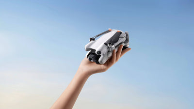
Complementing this heavy-lift fleet is the compact DJI Mavic 3 Enterprise (Mavic 3E), used for close-up inspections where agility and rapid deployment are essential. This combination of range and precision gives Portcoast a tactical advantage, enabling tailored operations from large-scale coastal mapping to targeted asset monitoring.
Software-Driven Results
Hardware is only half the equation. Portcoast relies heavily on DJI Terra for photogrammetric data processing and DJI Modify for quick editing and model generation. This end-to-end workflow shortens the data-to-decision cycle significantly. Survey teams can now conduct full-site assessments, process 2D and 3D models, and deliver insights to engineering teams in record time.
By automating key stages of the survey process, Portcoast has created a replicable model for digital twin generation, terrain analysis and predictive planning. DJI’s ecosystem gives their teams the tools to simulate future development, assess environmental impact, and engage with clients using visual data that bridges technical and non-technical audiences.
Real-World Impact At Baria Serece Port
The collaboration between Portcoast and Baria Serece, a port established in 1993, stands as a prime example of this innovation in action. Located in southern Vietnam, Baria Serece was the region’s first port, serving as a key logistics hub for decades. To maintain its competitive edge, management sought a way to modernise operations and improve productivity.
By partnering with Portcoast and adopting DJI’s drone solution, the port gained a powerful digital upgrade. Precise aerial data collection replaced slower ground surveys. Staff exposure to hazardous environments was minimised. Most critically, decision-makers now benefit from visual data outputs that support confident infrastructure planning.
This has translated into faster project delivery and measurable cost savings.
Benchmarking A New Standard In Marine Engineering
The Portcoast case study sets a compelling benchmark for coastal engineering firms globally. By embracing drone-based workflows, they have proven that precision, efficiency and safety can be scaled without compromising on data quality.
For the UK’s port infrastructure sector, where regulatory compliance, climate resilience and digital transformation are front of mind, Portcoast’s approach offers a ready-made template. The integration of DJI Matrice 350 RTK with modular sensor payloads and post-processing tools is not just a technical upgrade; it represents a shift in operational culture.
From tidal zone surveys to harbour construction and erosion monitoring, drone data is fast becoming indispensable. Portcoast’s success shows how to operationalise that data across the project lifecycle, creating lasting value for clients and communities alike.
Conclusion
Portcoast’s work with DJI enterprise drones is more than a case study in innovation; it is a blueprint for the future of port and coastal engineering. With the right drone platform and data infrastructure, engineering firms can unlock new levels of insight, speed and safety in their operations.
Explore DJI Enterprise drones and discover how your organisation can transform infrastructure projects with intelligent aerial solutions. Visit the Coptrz official online store here to view the full range of enterprise drones and accessories today.


